The 1969 Wooster Flood
- Home
- Economic Development
- Exhibits
- The 1969 Wooster Flood
revised by Glenna Van Dyke

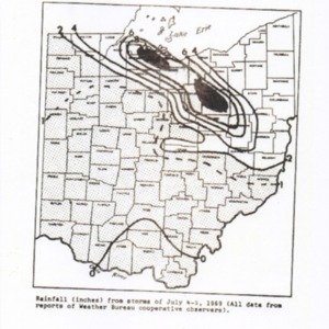
On July 4th 1969, at about 6:00pm, forecasters for the National Weather Service detected storms forming over central Michigan, but they expected the storm to mostly avoid Northeast Ohio. These early forecasters were gravely wrong. One hour later, the storm unexpectedly veered over Lake Erie and gained momentum as it hurtled towards Northeast Ohio. The forecasters then tried to warn those in its path of danger, but because it was a holiday the Civil Defense office in Cleveland was closed. They were instead forced to go through local police departments. 2

The Senior Forecaster on Duty, George W. Webb, sent out severe weather warnings at 7:35pm, and again at 7:45pm. Fifteen minutes later, the storm made landfall near Lakewood, Ohio. However, flash flood warnings didn’t yet exist, leaving the residents of Wooster in the dark about the imminent disaster. 3 Crowds gathered at the L.C. Bowles Golf Course to watch fireworks and others visited family, but no one was expecting a flood. 4
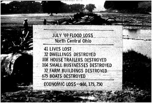
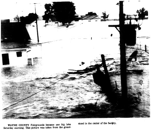
The next morning, Wooster residents were shocked as they woke up to find their city torn apart by over 726,016 tons of water per square mile. The exhausted creeks and streams gave way and highways, homes, and fields were ravaged beyond recognition.5 While the nation watched astronauts fly to the moon and the chaos unfolding in Vietnam, Wooster residents were forced to recover from one of the worst floods in history.
Why Wooster?

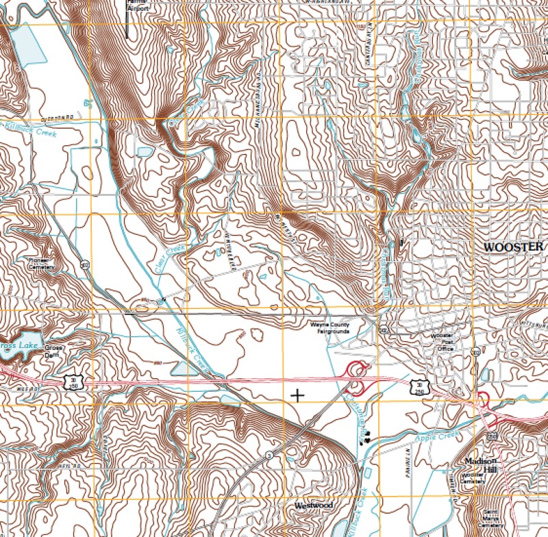
Locals know that Wooster isn’t surrounded by any major rivers, and its main creek, the Killbuck Creek, is only about 50 feet (15 meters) wide. Why, then, was Wooster struck with such a disaster?
The answer lies in Wooster’s geography. A long, flat valley runs across the southwest end of town, and follows the Killbuck Creek. The creek itself also has very shallow banks. This valley is known as the Killbuck Valley and was carved out by glaciers about 19,000 to 20,000 years ago in the “Last Glacial Maximum”. The low-laying areas of Wooster were once a lake floor formed by these receding glaciers.
In 1969, this flat area was home to several farms that were destroyed by the flood. In July, it was too late to replant crops and too early to harvest. Crops that were left in the fields were damaged by soil erosion and bacterial infections, causing devastating losses for farmers. 2 Thus, floods in July are cause even more damage to farmers. 3
Wooster Awakens to the Flood: July 5th
At 5am on July 5th, 1969, Mayor Paul Tilford woke up to a heart-sinking call. On the other end was a Wooster police officer, who brought terrible news. Several people, including two officers, had been swept away by a massive flood the night before.1 This was just one of many panicked calls that were made as Wooster residents woke up to the destruction in the early morning hours. Many called emergency services while others called the Wooster Daily Record. City call reporter Bee Collins told of a woman minutes away from drowning. 2
During the crisis, communication was vital. REACT (Radio Emergency Associated Citizen Team) played a crucial role in the hours following the flood, and members directed traffic and provided stable communication for rescue efforts, aiding local police. They became Wooster’s primary communication network and distributed important information to Wooster’s radio stations and authorities when other means of communication had been destroyed. 3
What of the missing officers? Two of them were found, but unfortunately the other two were killed when their rescue boat capsized, joining the 27 that lost their lives to the flood. 4

For more information, view the flood map.
A Community Recovery
After the flood receded, Wooster residents were left to pick up the pieces. When water service returned on Tuesday, July 8th, there was only limited celebration; the flood damage had forced Wooster’s water to bypass treatment and wastewater was ejected into the Killbuck Creek. Naturally, many had health concerns. 2


Wooster residents however came together to help rebuild the city. Volunteers of all ages gathered for Operation Clean Sweep. 3 Wayne County 4H clubs, even one from Rittman, also helped to clean the Wayne County Fairgrounds. 4 They hoped to resume the County Fair in early September. 5
Wooster’s Flood Control Efforts
“Next Monday our astronauts will land on the moon. When our nation can do such a marvelous feat as that, surely we can do something to save such destruction of lives and property[.]”
– Mayor Paul Tilford, Testimony before the Subcommittee on Flood Control, July 19, 1969
On July 19, 1969, the Subcommittee on Flood Control came to Wooster’s Municipal Building and spoke to several locals, including Mayor Paul Tilford, about the damage that had been done and how the government could help.
Mayor Tilford called for a federal flood control study and plan for action and the Army Corps of Engineers and Colonel Maurice Roush quickly agreed to come to Wooster. 1 However, the implementation of this plan would take longer. Community members formed the Killbuck Watershed Association, which sought to coordinate local flood control. On October 15, 1969, it was formally named the Killbuck Watershed Conference at the OARDC Auditorium, and in 1970 successfully filed for federal aid under Public Law 566, which authorized funds for small watershed projects. 2
However, it would take until 1982 for Tilford’s call to be answered. The USDA Soil Conservation Service performed a Flood Hazard Study, which provided floodplain maps to help Wooster begin the task of flood control. 3 In 1984, Wooster would conduct the first flood control assessment. Finally, it seemed that Wooster would be safe from future floods.
View Timeline: The Path to Flood Prevention
Legacy of the Flood
Most people expect flood control, especially of watersheds near lots of people, to consist of dams, reservoirs, and other structures.1 However, these sorts of structures wouldn’t help to control the Killbuck Watershed. In fact, in 1984, the USDA Soil Conservation Service found “structural flood control” methods to be infeasible. 2 It would take more creative methods to tame the Killbuck Creek.
Instead, the USDA’s final recommendations were “non-structural” methods such as temporary flood shielding, blocked off basement windows and a single low-earth dike for buildings across Wayne County. For agriculture, they recommended methods that would reduce soil erosion, such as contour farming and soil tillage, in case a flood did come.3 As Wayne County focused on modifying land use instead of controlling the flood, this trend spread across the country. Government officials realized that physical structures like dams and reservoirs created a false sense of security and led to more damages, especially to the environment. 4
Today, there is no sure way of preventing Killbuck Creek from flooding and the recommendations of the 1984 assessment, if followed, are estimated to reduce flood damages by $23,300 or 16%.5 Instead, local organizations try to help residents, businesses, and farmers deal with flooding. The Wayne County Soil and Water Conservation District helps prepare buildings for flood, clear log and ice jams that lead to floods, and educate locals on conservation practices.6 Wooster and Wayne County both enforce flood regulations that limit or outlaw development to protect the environment and communities. The Wayne County Emergency Management Agency also closely watches flood conditions and could provide rescue assistance if needed.
Through remembrance and community action, Wooster residents turned devastation into hope by ensuring disaster like the 1969 would never strike Wooster ever again.
Sources by Section:
1- William P. Cross, “The Flood of June 1946 In Wayne and Holmes Counties, Ohio,” Water Resources Board (Columbus, Ohio), March 1947, p. 26 2- Soil Science Society of America, Farming after the Flood, https://www.soils.org/files/science-policy/caucus/briefings/farming-after-flood.pdf 3- Cross, “Flood of June 1946,” p. 17.
1- Paul Tilford, “Statement of Hon. Paul. E. Tilford, Mayor of the City of Wooster, Ohio” in Ohio Storm Damage Inspection: Hearings before the Subcommittee on Flood Control of the Committee on Public Works, House of Representatives, (Washington: U.S. Government Printing Office, 1970), p. 257. 2- Elinor Taylor, “Once Every Hundred Years Is More Than Enough,” Daily Record (Wooster, OH), Special Section, July 3, 1989, p.1. 3- “Red Cross, REACT In Heroic Tasks,” Daily Record (Wooster, OH), July 8, 1969, p. 3. 4- “12 Feared Dead In Flood,” Daily Record (Wooster, OH),Vol. LXXVI, No. 26, July 5, 1969, p. 2.
1- Richard Horn, “Wooster Water Works Employes Fought Hard To Restore Service,” Daily Record (Wooster, OH), July 9, 1969, p. 29. 2- U.S. House of Representatives, Ohio Storm Damage Inspection: Hearings Before The Subcommittee on Flood Control Of The Committee on Public Works (Wahsington: U.S. Government Printing Office, 1970), p. 260. 3- “Adults, Teen-Agers Join In Operation Clean Sweep,” Daily Record (Wooster, OH), July 22, 1969, p. 47. 4- “Help Clean Up,” Rittman Press (Rittman, OH), July 16, 1969, p. 4. 5- “Wayne Co. Fair Entries Will Close On Saturday,” Daily Record (Wooster, OH), Aug. 26, 1969, p. 13.
1-U.S. House of Representatives, “Ohio Storm Damage Inspection: Hearings Before The Subcommittee on Flood Control of the Committee on Public Works,” Washington: U.S. Government Printing Office, 1970, pp. 261-263 2- USDA Soil Conservation Service, “Killbuck Creek Flood Hazard Study, Wayne County, OH,” USDA Soil Conservation Service: Columbus, Ohio, August 1982
1- James M. Wright, “The Nation’s Responses To Flood Disasters: A Historical Account,” Association of State Floodplain Managers, April 2000, http://www.floods.org/PDF/hist_fpm.pdf 2- USDA Soil Conservation Service, “Watershed Plan and Environmental Assessment for Upper Killbuck Creek Watershed,” September 1984 3- Ibid. 4-Wright, “The Nation’s Responses To Flood Disasters,”http://www.floods.org/PDF/hist_fpm.pdf
5- USDA Soil Conservation Service, “Watershed Plan and Environmental Assessment for Upper Killbuck Creek Watershed,” September 1984
6- U.S. House of Representatives, “Ohio Storm Damage Inspection: Hearings Before the Subcommittee on Flood Control of the Committee on Public Works,” Washington: U.S. Government Printing Office, 1970, p. 246.
7- Wayne County Soil and Water Conservation District, “Providing Assistance for You! (brochure),” Wooster, OH.
How to cite this page:
MLA: “The 1969 Wooster Flood.” stories.woosterhistory.org, http://stories.woosterhistory.org/the-1969-wooster-flood/. Accessed [Today’s Date].
Chicago: “The 1969 Wooster Flood.” stories.woosterhistory.org. http://stories.woosterhistory.org/the-1969-wooster-flood/ (accessed [Today’s Date]).
APA: (Year, Month Date). The 1969 Wooster Flood. stories.woosterhistory.org. http://stories.woosterhistory.org/the-1969-wooster-flood/
A special thank you to the Wayne County Soil and Water Conservation District and to Professors Shelley Judge, Hayden Schilling, and Greg Wiles of the College of Wooster. These institutions and individuals contributed time, guidance, and resources that were crucial to the final product.
Valuable resources used in this exhibit also came from the Daily Record, the United States Geological Survey, the National Weather Service, the Soil Conservation Service, and the Federal Emergency Management Agency.

